Wednesday, May 24, 2017

North West Coast, New Zealand South Island – April 17th – 18th, 2017

Perhaps you’re asking yourself: How did we know where to camp (if not, too bad, I’m answering your fictitious question anyway)… well, New Zealand in all its glory, created an app that tells you where you can camp with the type of campervan you are driving. Since we sprung for a fully self-contained van (equipped with a grey water tank and portable toilet that you take outside to use), we were able to camp for free most of the time in random parking lots throughout the country. One such parking lot was at the end of a dirt road which dead ends at the coast. When we arrived, we were confused to see a plastic rope strung across the road. Assuming it was a temporary barrier for livestock, we took it down, drove through, and restrung the rope. What we did not anticipate was it was a temporary barrier to contain horses that pulled a legit covered wagon. Yes, I am not shitting you, a kooky, barefoot, prospector-esque man and his barefoot hillbilly daughters were camped out in an old covered wagon pulled by two horses, while the third horse was ridden alongside the wagoneers. Prospector Joe (that may or may not be his name) was quite friendly, so we got the whole scoop and even saw them traveling on the paved road the next day while several companions walked on foot like they were on the Oregon Trail (just like the computer game – gotta watch out for dysentery, Indians, snakes, and hunger!).
Coastline camping with covered wagon pioneers.
The next day, we did several short hikes along the route south:
  1. Fail. One km in the trail was closed thanks to the earthquake several years back. Thanks a lot earthquake.
  2. Fail. The tide was too high to explore all the coast at Cape Foulwind (for the record, the air was not foul).
    Charming creek walkway and Cape Foulwind.
    1. Success! A hidden gem (literally hidden in a local’s backyard)! As instructed by Scott, we parked along the road, walked over an old historic bridge, checked out an abandoned mystery tunnel, then meandered through somebody’s lawn to a surprise massive Maori sea cave! Super cool – see the pics!
      Maori sea cave.
    2. A quick walk down to a beautiful cove along the Truman Track.
      The Truman Track.
    3. Small boring cave with a cool sun beam coming through. This was not recommended by Scott, should have known it would be dull. It’s possible our cave standards have been far too inflated for our own good.
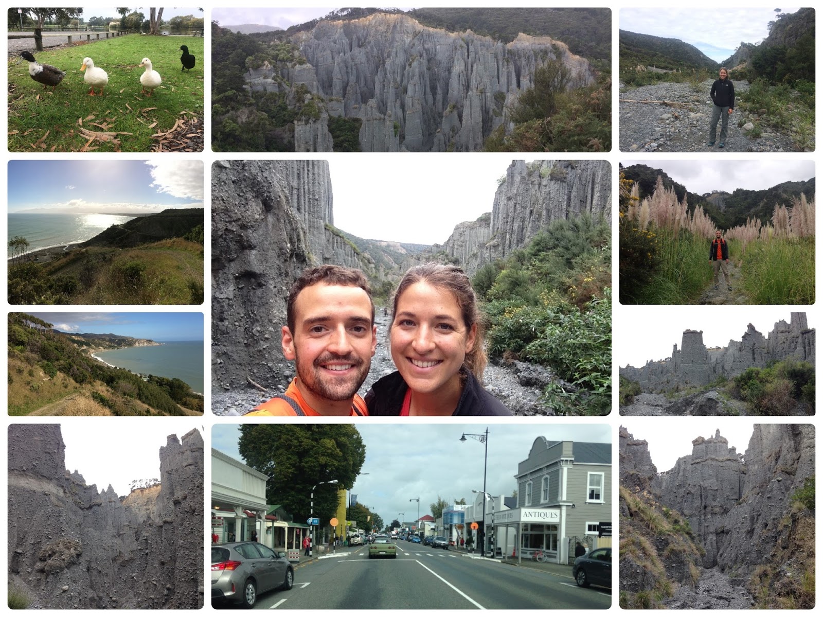
    4. Sometimes places are touristy for a reason. Pancake rocks is definitely one of those places! There were cool pancake rock structures, blowholes, a huge surge pool, crashing waves, and a hole righteously named, “sudden sound” for the sudden sound that emanated from the hole when the water rushed in. Although we visited at high tide, the surge was low that day, making the blow holes and crashing waves not quite as spectacular as normal. Oh well, can’t have it all.
    After six short hikes, not to mention five full days without a shower, it was likely time to spare our fellow campers (and each other) from the pungent smell we had acquired. Consequently, we stopped for showers at a campground and finished the evening off at a local brewery where we enjoyed comfy leather couches, a fire, and some quality beer/cider. Another amazing day in paradise.  
    Pancake rocks and a well deserved beverage.


    Nelson Lakes, New Zealand South Island – April 16th – 17th, 2017

    A quick stop over at Nelson Lakes proved to be well worth the effort. After a beautiful drive through a wide glacier valley and another night in Freddy, we got up early(ish) and hiked Mt. Robert loop, a 9.5km (~6 mi) track through high alpine with views overlooking the entire region. Although the 360 degree view at the 1431m (4695 ft) summit was hindered by clouds that chose the perfect opportunity to creep in while we were ascending, it was still a stunning hike and we were in relative isolation for most of the journey. After returning to the van, we ate a quick lunch before continuing on to the west coast.  
    Mt. Robert Loop Track.

    Sunday, May 21, 2017

    Marlborough Region, New Zealand South Island – April 14th – 16th, 2017

    Our fuel management on the way to Cable Bay could have been better (guess we should have paid more attention during Andy’s Formula 1 races). Although gasoline in New Zealand is usually expensive compared to US prices (usually about $5.25/gallon), we ended up being forced to stop for a few liters of extraordinarily pricey gasoline (over $6/gallon!) just to get us to the next town, where we hoped the fuel would be more affordable. Not only was the fuel even more expensive in the next town, the only gas station did not accept international credit cards leaving us SOL. Luckily, a nice local used their card for us in exchange for cash money so we could buy more juice for Freddy. Crisis averted.

    Finally at Cable Bay, we did a steep hike to Sentinel Hill through sheep/cow pasture overlooking a magnificent bay. At the recommendation of Scott (the acclaimed NZ author extraordinaire), we made the hike a loop, descending off-piste (ski term meaning, “away from prepared ski runs”. After over a year of summer, I’m currently experiencing snow/skiing withdrawal) through a sheep flock (including one black sheep) onto a white sand beach surrounded by cliff faces. We finished the hike along the beach just as the tide was coming in. The entire hike was stupid beautiful. When I say, “stupid beautiful,” I mean, holy shit the views are so amazing that you literally turn thoughtless with your mouth open uttering exclamations like, “wow” and “woooah.” 
    Hiking Sentinel Hill. 
    Next on the day’s agenda, was a supposedly stunning drive out to Elaine Bay.  Unfortunately, the extraordinary view over bays, islands, and horizon galore were hindered by trees most of the time (pesky trees how dare they convert our pollution into breathable air in the way of my view). When we arrived, we set up camp on a patch of grass overlooking the bay, before heading out for a quick walk along the water. Although we beat the fast encroaching darkness, we were not so lucky with the rain, and returned to the van in a downpour… at least the weather was perfect earlier in the day.
    Camping at Elaine Bay.
    After a rainy night, we got up and hiked 10 km (6.2 mi) on Archer Track, a flat old forestry road along the coastline. We literally saw two people the entire hike and they were locals on a trail run. Again, the scenery was spectacular. Now back at Freddy, we drove the well-maintained 24 km dirt road to French Pass. The scenery along the drive to French Pass, made Sentinel Hill look like child’s play, and that was “stupid beautiful.” Daftly magnificent, ludicrously picturesque, or irresponsibly superb just don’t do French Pass justice. We enjoyed lunch at the bay with a handful of locals (apparently the tourists haven’t caught on to the splendor that is French Pass) at the end of the road before turning around and doing the drive again in reverse.
    Archer Track.
    The drive to French Pass.
     After successfully pulling off free illegal camping in an overcrowded parking lot (it was Easter Eve so we figured we’d get away with it), we went wine tasting in the Marlborough region (it was only too appropriate to consume the Blood of Christ on Easter… jokes 😊). Unlike the shitty weather and even shittier wine we experienced around Nelson, the Marlborough region did not disappoint. The wine was brilliant, the weather flawless, and the all-day Easter airshow was a serious added bonus! After getting our fill of wine, we spent a few hours watching the airshow. Well… to be fair, Andy spent a few hours engrossed by the airshow, while Paige and I had less of an attention span.
    Wine tasting in the Marlborough region.
    The Omaka Classic Fighters Airshow over Blenheim.

    Sunday, May 14, 2017

    Abel Tasman Region, New Zealand South Island– April 10th – 14th, 2017

    Our transit from the North Island to the South Island was via a 3.5 hour ferry that provided plenty of gorgeous scenery to test out the new camera! The highlight of the journey was the last leg of the voyage through Queen Charlotte Sound. From rolling green mountains hills sprouting all around us to the vibrant blue water, we had a feeling the South Island might actually be as special as everyone makes it out to be. Once on shore, we began a 5 hour road journey through more stunning landscapes to Pohara, where we would spend a few days with our friends Alan, Eileen, and Paige. With spectacular weather to boot, that drive brought us through wide flat vineyards, dry empty valleys, a pretty steep mountain pass, large blue bays, and, of course, lots of sheep pastures. To celebrate our friends joining us in New Zealand and to take advantage of the AirBnB’s big kitchen, we made homemade veggie chili for dinner!
    Our spectacular ferry ride from the North Island to the South Island. Dani's sporting her new gear!
    The weather was cooperating for our first few hours on the South Island!
    As the second cyclone of our New Zealand trip was scheduled to make our next few days very wet, we decided to get a big hike out of the way on the first day in the region. Under a cloudy sky that warned of the coming rain, we hiked for a few hours along the famed Abel Tasman Track up to Separation Point. Along the way, we saw Anapai and Mutton Cove beaches which were beautiful vibrant yellow beaches bookended by sandstone cliffs. It was very pretty in its own right, but it was a bit of a bummer since it would have been absolutely amazing if the sun was shining. Some more veggie chili for dinner and an improvised homemade apple tart sealed the day.
    Some photos of our hike in Abel Tasman National Park, including Alan pretending to be a duck.
    More of the beautiful coast of Abel Tasman National Park.
    The rain began overnight and didn’t stop for 48 hours. So, we made lemonade and went wine tasting (seriously, Dani did make lemonade from the lemon tree in the backyard)! About an hour away was the Nelson wine region, so after a bit of morning family yoga, we headed over. We went to four wineries, all of which were pretty underwhelming, but at least we lucky enough to end on the relative high note at Kahurangi Estate Winery. We sampled lots of sauvignon blanc and pinot gris, which we all typically enjoy, but were frustrated to find they were all very far from the clean and citrusy wines New Zealand is known for. Perhaps we were unlucky in our winery choices, but, hey, it was mostly free and we still had a fun rainy day sipping on wine!
    Check out those wine-tasting-amplified smiles!
    We tried to make the most of our second rainy day by attempting a few short hikes. The first was a fail. After about 100m, we found a swollen stream blocking our path. Not wanting to have to deal with taking our shoes off in the pouring rain, we decided to skip Rawhiti Cave. Instead, we went to a hike up to Wainui Falls. After 30 minutes of walking along a yellow-orange tinted river (odd, but must be from all of the livestock in the area), we arrived at the roaring falls, officially soaked. At least the rain made the falls even more impressive than normal! For our last hike, we went to the Grove Scenic Reserve where a 1km loop brought us through some very prehistoric feeling jungle and rock formations, very cool! Satisfied with our hiking efforts in the pouring rain, we went back to the AirBnB for some warmth, dryness, and, yes, more yoga.
    Our last day of hikes was marred by lots of rain, but still beautiful!
    The next morning, after a sad goodbye to our friends Alan and Eileen, we packed up Freddy and pulled away from the most comfort we’ve experienced in 3 months. In good news, our duo became a trio, as we happily welcomed Paige along for our next two weeks in Freddy through the South Island!

    Tuesday, May 9, 2017

    Wellington, New Zealand North Island – April 9th – 10th, 2017

    We spent a full day in Wellington, before reluctantly saying goodbye to the north island. When we arrived, the first thing we spotted was the EXACT cruise ship that we had taken to Alaska with Andy’s family in 2015! Celebrity Solstice is apparently a bit of a whore (she gets around). After this crazy coincidence, the best parking spot in the city freed up right in front of us as soon as we approached the downtown area! It was going to be a great day! From our VIP spot, we walked directly across the road to the farmer’s market. When I say, “directly across the road,” that is exactly what I mean – we literally Asia style jay walked right in the middle of busy Sunday morning traffic. Oops, gotta remember what country we are in. The farmer’s market was hopping with locals picking up fresh fruit and veges (NZ spelling) and enjoying the food trucks along the harbor. Of course, we joined in, stocking up on produce and indulging in fresh fruit ice cream, which is SO good! They have this special machine which mixes a brick of ice cream with fresh fruit of your choosing. I repeat: SO GOOD! After storing our purchases in the van, we walked back across the street (this time using the cross walk) to the Te Papa museum. We spent a couple of hours at the impressive free museum walking through exhibits on earth science, NZ animals (native vs. imported), NZ in World War 1, and Mauri culture. The visit was only hindered by the Sunday crowd, which was made exponentially worse by the cruise ship crowd.
    Pics from around Wellington.
    Once we had our downtown fill, we took the coastal road through the suburbs of Wellington, stopping along the way to enjoy a cider/beer overlooking the picturesque city. It was a beautiful day, we couldn’t have asked for better weather (well… maybe 5 degrees warmer would have been nice). Based on Scott’s recommendation, we next played a round of mini golf at an eccentric metal art gallery / homemade mini golf course. Even though the ball never rolled where you actually hit it, we had a blast (Andy would like it mentioned that he won). As the sun was beginning to set, we made our way to a free coastal parking lot to crash for the night. The sunset was the perfect end to a perfect day (with the exception of the 5-degree temperature differential… if we’re being absurdly fussy).

    Wellington area coastline and the sunset from our camp spot.
    Mini golf at Carlucci Land. Notice the Honesty box and credit card machine for paying. 
    Before catching the early morning ferry, we met up with our good friends Alan and Eileen at their hotel for breakfast. They had arrived in New Zealand a few days before to visit Alan’s family and yours truly. The five of us (including Eileen’s daughter, Paige), had planned to spend 5 days together in Pohara on the northern coast of the south island. We were thrilled to see them and excited to spend some quality time together! Before temporarily parting ways, they offloaded the excessive amount of stuff they had graciously brought with them from the US – the most exciting of which was a BRAND NEW FANCY PANTS CAMERA! You can expect photo quality to improve significantly in future posts. YAY!   
    Saying goodbye to Wellington and the north island.

    Cape Palliser, New Zealand North Island – April 8th – 9th, 2017

    We have a theory (then a rant): If your culture supports a healthy work-life balance and encourages spending time outdoors with your family and friends, you will be happier and thereby tend to be less stressed and kinder to others. As far as we can tell, the Kiwis, are, in general, easy going and ridiculously nice people that go out of their way to help each other out, even strangers. Conversely, a culture which places more emphasis on work and “success” tends to breed more abrupt people on a mission, who can’t be bothered, because with all of life’s responsibilities, there is little time or bandwidth for genuine compassion (cough cough… America – don’t get your feathers in a ruff, of course, there are always exceptions and very nice compassionate people in America too). Nuff said, here’s an example: While on our way to Cape Palliser, we came across yet another, “Road Closed due to Flooding” sign. After asking some friendly locals, they suggested that we drive up there anyway, because they think it should be open by now. Unfortunately, the road was still closed, but not because the flooding was too bad, because the council hadn’t gotten around to opening the gate yet (they were likely enjoying life). Never fear though, a local farmer and his dogs were spending the morning happily shuttling cars through the first gate (which was unlocked) and on back roads through his property to bypass the locked gate. Thanks Kiwi Farmer, you saved us an hour detour!


    Our first stop on the southern tip of the north island was the pinnacles at Putangirua Scenic Reserve for some Lord of the Rings scenery. Here, the mountains have eroded leaving towering spires and pinnacles protruding from the dry stream bed below. After exploring the sandy skyscrapers, we continued up through the brush to an overlook viewpoint, before completing the loop with stunning coastal views the entire way. Loved it! Although the pinnacles hike was unique and incredible, for me, the next stop triggered the childlike excitement of a kid on Christmas morning – a seal colony with curious baby seals everywhere! Andy had to tear me away so we could make it in time to climb the 250 steps to the base of Cape Palliser lighthouse to watch the sunset. It was an amazing day!

    The drive from Mt. Taranaki to Cape Palliser and the pinnacles at Putangirua. 
    Seals!
    Cape Palliser lighthouse and coastline.

    Taranaki Region, New Zealand North Island – April 5th – 7th, 2017

    Did I mention Cyclone Debbie? Oh ya, in addition to ruining our plans in Taupo / Tongariro National Park, Debbie also attempted to sideline us on the way to the Taranaki region. We left Taupo in search of better weather (or if else fails at least lower elevations), but road flooding closed the only two routes to our backup destination (including the scenic route – not that you could see it through the rain anyway). To make matters worse, we did not figure this out until we had driven several hours in the direction of these closed roads. All said and done, the ~350 km, journey turned into over 500 km and 8-hours of driving! Alas, Debbie didn’t stop us, because we made it to Mt. Taranaki (a Mt. Fuji-esque mountain) just before nightfall. Perseverance wins.

    Now on the west coast of the north island, we hurriedly explored the black sand beach and caves below our cliffside camp spot at Waverly beach before the tide came up and the sun went down. Now firmly off the beaten path, we were the only campervan in sight and had the entire incredible coastline to ourselves. Admittedly, the weather may have played a role in our solitude, since it was raining, only a few degrees above freezing, and the wind was threatening to blow over poor Freddy. When we woke the next morning, the weather was surprisingly improved and we made our way to an absolutely stunning hike through cow pastures which overlooked dramatic white coastal cliffs and returned along a pristine beach. The only downside to the hike was that Debbie had relieved herself all over our trail making it a sloppy muddy mess. Thanks to Debbie and the non-existent traction on my now very worn shoes, I ended the hike well fertilized in a mud + cow manure mix. Thanks again Debbie. You won that round. Debbie: 3, Dandy: 1 (participation point).
    Curious cows en route and Waverly beach. 
    White Cliffs walkway poop (I mean loop).
    Before heading up to the eastern plateau of Mt. Taranaki to camp, we explored a black sand beach littered with, no not trash, this isn’t Asia, but arches and other fascinating rock formations. We stayed and explored as long as we could before we were forced to take off our shoes and wade through the cold incoming tide back to van. The drive up to the Mt. Taranaki Plateau and the view at the top did not disappoint. The single peak emerges 2518 m (8261 ft) above the plains and thanks to the national park regulations, a perfect boundary circumnavigates the base of the peak where the forest has been cleared for pastures. What we did not consider when deciding to camp at the highest drivable spot on the north island, was the temperature when the sun went down. It was the first night in Freddy that we truly froze. Once again, our solitude at the car park camp spot could easily be explained the weather (and our insanity).
    Three Sisters black sand beach.

    The next morning, we did a long hike in Taranaki National Park. A combination of stupidity and underestimating how long it would take to navigate the muddy trail left us about 4-hours in, drenched, cold, and starving (first rule of hiking – bring snacks)! Luckily, tourism came to the rescue in the form of a mountain café where we enjoyed cheese scones and tomato soup made from scratch while we waited out the rain. It was beyond glorious! The clouds even cleared on the way back giving us a spectacular view of the towering mountain. 
    Mt. Taranaki and our mishmash loop hike: Enchanted track to Waingongoro track crossing the Waingongoro Gorge to Waingongoro Hut to Ridge Loop track to Dawson Falls to Kapuni Loop track to the Visitors Center and CAFE! to Wilkies Pools Loop track and finally back to the car park.

    More pics from Mt. Taranaki hiking. The half mannequin man occupied a bunk in the visitor center historic hut exhibit.

    Pics from around the region including the remains of a 1923 ship wreck.

    Roturua and Taupo Regions, New Zealand North Island – April 2nd – 5th, 2017

    After arriving in Roturua, an area well known for geothermal activity, we stopped at a visitor’s center for a little WiFi action. After spending the previous week struggling to find information that would get us off the main tourist path, we broke down and spent $12 on the pdf of a book we had failed to find in Auckland. Spoiler alert: This purchase ended up elevating our New Zealand trip from touristy, but still incredible, to off the beaten path, EPIC! The book, “New Zealand Frenzy,” is a witty adventure travel guide which aims to let you in on the secret spots and best hikes around NZ – perfecto! After exploring the city of Rotura for a few hours, we settled in at a free campsite (parking lot), and spent the rest of the evening planning.

    Geothermal features around Rotura. Steam literally seeps through the sidewalks cracks (and we thought we had foundation problems) and bubbling mud and other features are fenced off at the local park. 
    With a detailed plan in place, we had a busy day in store. First thing in the morning, we went on a trail run up a hill which overlooked the city of Rotorua and the Te Puia thermal area (running is faster than walking and, as I mentioned, we had a lot planned). Unlike Yellowstone, where the geothermal features are within the National Park, NZ has allowed companies to open zoo-like attractions for geysers, mud pools, and hot water lakes – Te Puia is one such attraction. Each park costs around $50 NZD (~$35 USD) and there are at least 3 of them in the Roturua area. One park even adds a bag of soap to a geyser hole at a scheduled time each morning to artificially make the “natural” geyser go off! Psst, secret… Yellowstone is way better. Regardless, our book purchase already more than paid for itself, since the morning overlook gave us a birds-eye view of the entire Te Puia attraction, including a geyser! 
    Trail run to a view point over Te Puia and Rotura. 
    Next, we made our way to watch rafters and kayaks take the plunge over the world’s highest commercially rafted waterfall. Unfortunately, the cold cloudy weather seemed to be keeping the thrill seekers away so we didn’t see anybody go over the waterfall. Oh well, the short hike which included a cave and staircase cut into a rock wall was was nice regardless. Our next venture was a hike up Rainbow Mountain for stunning views over the area. The hike was made even more phenomenal because the surrounding cliffs were steaming and the clay-like soil was a crazy mix of colors, hence the name “Rainbow Mountain.”  Under Scott’s (the author’s) instructions, we subsequently drove out to some bubbling mud pools right outside yet another pay-to-enter attraction. We had a good time laughing at the burping, farting sounds emanating from the mud. From here, we parked in the tourist lot (suckers!) and walked the other direction to take a dip in a secret hot spring equipped with a hot water waterfall! In addition to the free price tag, we were the only people there! Thanks Scott!
    Short hike to the highest commercially rafted waterfall.
    Hike up Rainbow Mountain.
    Bubbling mud ponds and our private natural hot spring waterfall pool.
    Another blast from the past photo of my mom, sister, and me taken at the same bubbling mud pond 20+ years earlier. 
    Thanks to the remnants of a Cyclone Debbie which had hit Australia a few days before, it poured rain for the next three plus days. We aren’t talking about a sprinkle here, the sky actually opened and a waterfall of rain fell on top of poor Freddy (the van) while we twiddled our thumbs inside, hoping the weather forecast was wrong. For once, the weatherman was accurate, and we were forced to change plans and abandon Tongariro National Park and the famed “Lord of the Rings” scenery. We didn’t even get the hint of a view while passing through some of the most beautiful scenery in NZ (twist our arm, I guess we’ll have to come back). Regardless, before leaving the area, we managed to visit a cheap geothermal park ($5) with a nice walk around massive steaming craters and two water features: Huka Falls, a waterfall made brilliant by the bright blue color of the water, and Aratiatia release, a scheduled dam release which was underwhelming at best. In my imaginative mind, the dam gates thrust open and a wall of water surged forward to flood the river. In reality, the gates eased open (really just a crack) allowing a small spray to gradually fill the river bed, yawn, booorring. In our misplaced excitement, we even arrived an hour early, scoped out the best viewing spot, and took before and after photos (which to be fair are actually quite impressive). If only it had been a step function instead of a low slope ramp… sorry nerded out there. Last but not least, while in Taupo, we also attempted to soak in a free hot spring river (emphasis on the word “attempted”). First, we ran around for 20-minutes in only our swimsuits in the freezing cold pouring rain trying to locate the spot. When we finally found it, we excitedly eased into the water only to discover that the cold rain had diluted the hot water making it a chilly, lukewarm temperature. Fail. 

    Kuirau Park.
    Aratiatia release (top; top-right is the before pic and top-middle is the after pic) and Huku falls (bottom).